Discovery day
The year was 1975. We'd spent '72 through '75 camping and exploring Ontario's Provincial Parks in the Sudbury area and west to Lake Superior Park. We also traveled the roads around Chapleau and Elliot Lake placing our tent in a park for a few days and then moving on.
We always had our canoe along and used it for day trips away from our campsite and for fishing.
We'd also experimented with a three day trip in Killarney Park and a week long trip starting and ending in Restoule Park ... it was time to expand our horizons
Since I worked within walking distance of Queen's Park I was familiar with the map office and the location of the Ministry of Natural Resources.
I'd visited several time to get information about parks and the canoeing opportunities in and around some of the parks we'd visited.
I chanced by the office one day looking for canoe route information in the area north of Sudbury and extending as far west as Lake Superior.
It must have been my lucky day ... or most of the staff may have been at lunch ... because I was given the run of a filing cabinet full of routes ... all with maps and route descriptions which included portages.
I consulted the big map on the wall as I filled a folder with pamphlets and mimeographed sets of documentation.
Over the next few weeks I went through all the stuff I'd collected looking for some circle routes that we could attempt.
It all paid off
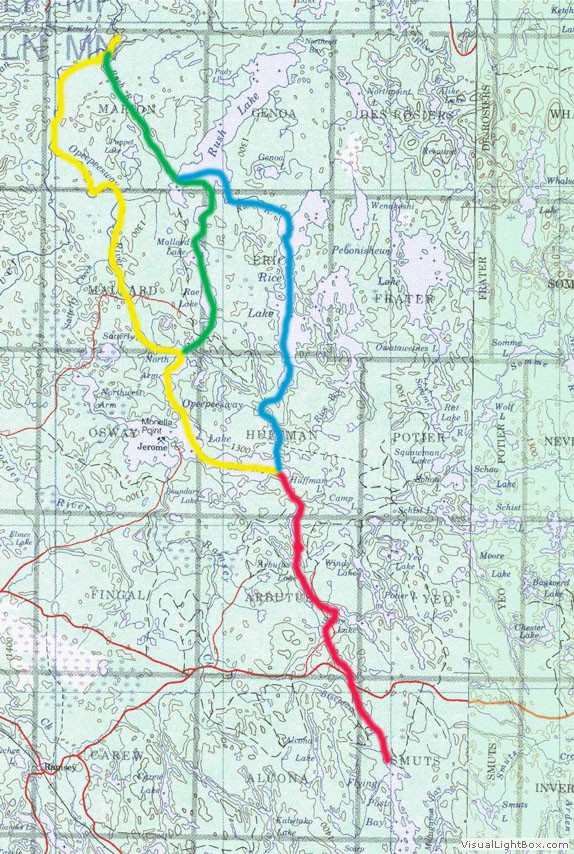
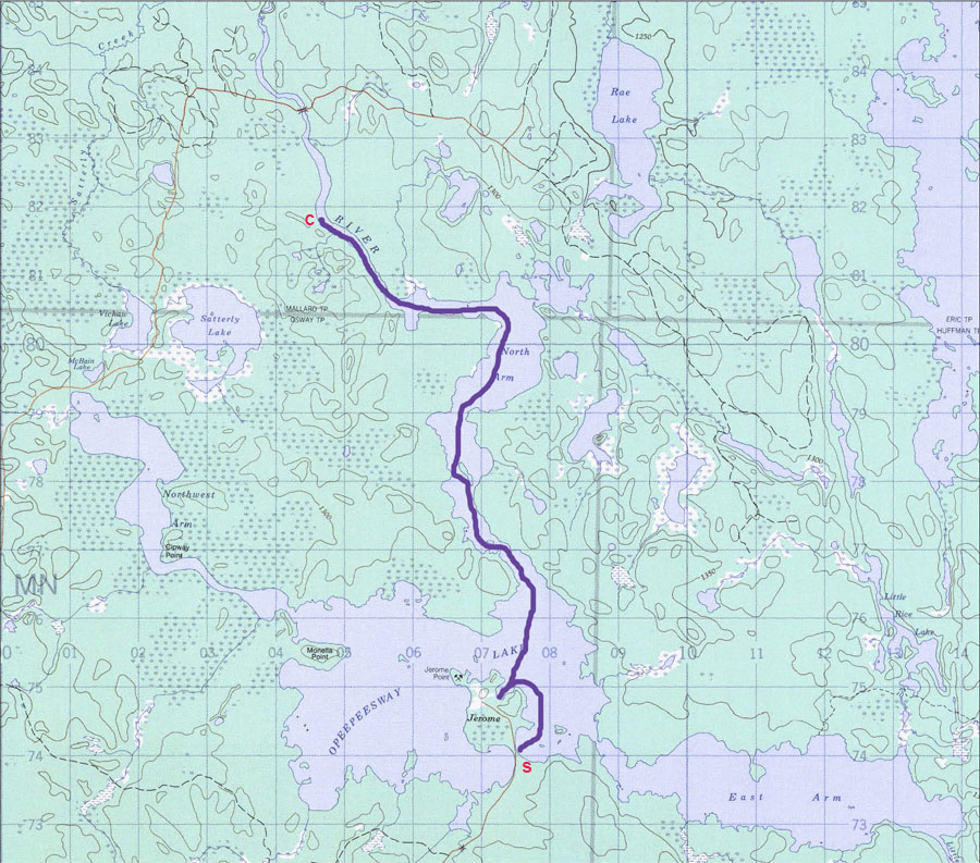
First take a look at the map I've drawn to depict the possible routes.
Original Map
The original route ... in red ... began at the town of Biscotasing and went north through Flying Post Bay. It then followed a stream for a bit before portages were necessary to get to Dismal Lake, Stoney Lake, Arbutus Lake and finally Opeepeesway Lake.
Arriving on Opeepeesway there were three possibilities ...
Turn west and follow the yellow brick road to the outlet of Opeepeesway Lake and down the Opeepeesway River to meet the Woman River and finally to Horwood Lake.
Go to the northernmost bay on Opeepeesway Lake and portage to Rae lake ... in green ... and on to Rush Lake where you turn west and north to the outlet and follow the Rush River down to the Woman River.
Go north through Little Rice and Rice Lakes ... in blue ... and descend the Rice River to Rush Lake where you join the previous route.
Also notice that there appears to be road access at the town of Jerome on Opeepeesway Lake and to the Opeepeesway River just after it leaves the lake.
Another trip to Queens Park to buy the topographic maps so that I could assess the possibility of traveling the rivers in both directions ... a call to the Ministry office in Chapleau to verify my observations ... and a call to the Ramsey Paper Company to check on permission to use the roads (this was 1976 and you needed permission to use the roads).
According to the Ministry the portages were open and I could expect good fishing for walleye in Opeepeesway and in Rice Lake; pike were the predominate species in Rush Lake.
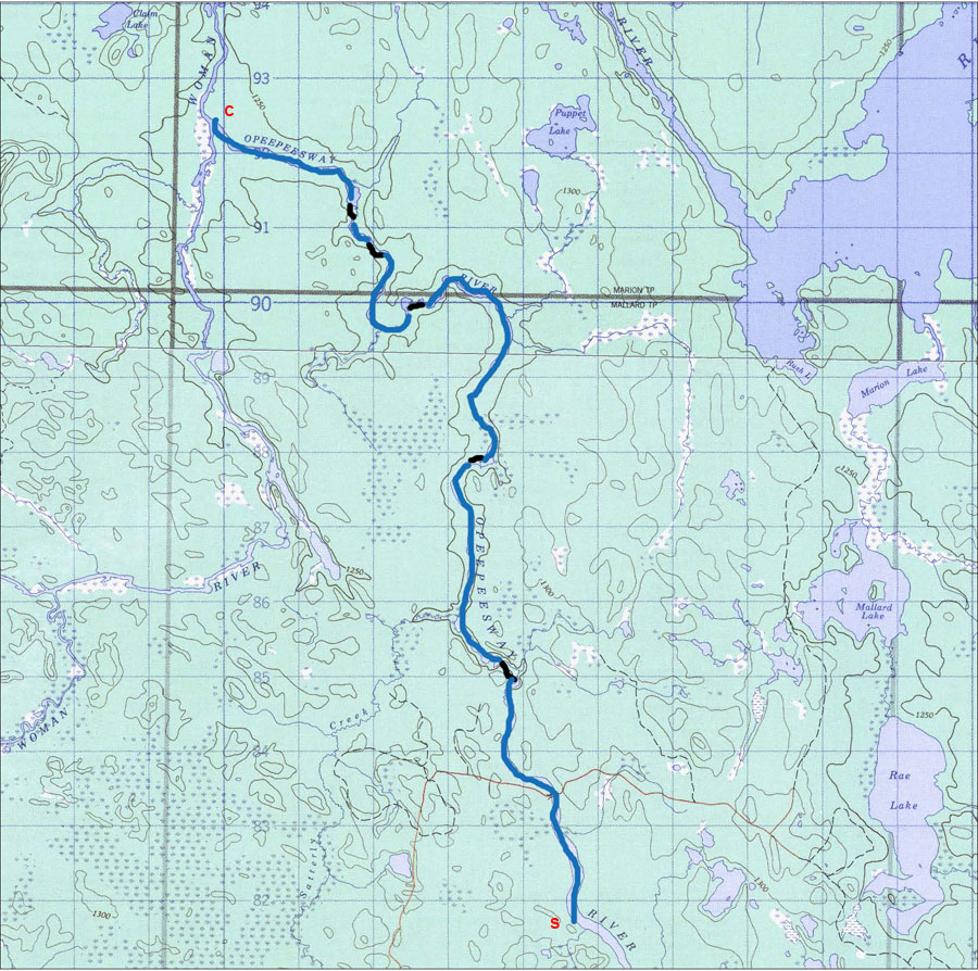
A little research showed that there was a ghost town at Jerome so we thought that we'd put in there in order to spend some time walking around the townsite. Then we'd travel down the Opeepeesway River and up the Rush River to access Rush Lake. There were supposed to be some nice beaches on Rush so we didn't plan to travel any further on our first trip ... just out and back.
We chose the river route since the topo showed an extensive marsh from Rae Lake through to Mallard and then to Marion ... we thought that we'd explore those lakes by taking a day trip south from Rush.
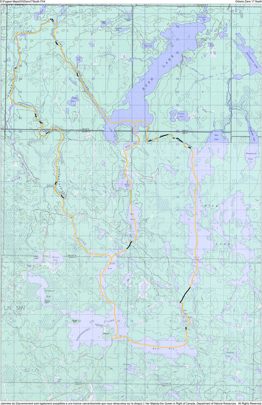
When it's all distilled down here's a map of the possible circle routes from Jerome
1976 Route Map
That first trip
Remember here that the year is 1976 ... Ramsey Paper controls the roads and require check in and out at a booth near Highway 144 ... they only allow traffic after 7pm ... the GPS does not exist so we're finding our way by map and compass.
We check in with Ramsey Paper and find a spot near 144 to rest in the shade until 7 ... then we start out on the Sultan Road looking for that turn off to Jerome.
I try to navigate using the compass and the topos but there are no mileage markers on the road so I'm trying to keep track of the logging roads that go off in a northernly direction ... almost usless since new roads have been cut in since the map was printed.
Without realizing it I pass the road to Jerome and wind up on the road to the bridge over the Opeepeesway River ... by the time I realize my mistake and get us back to the Sultan Road, find the road to Jerome and get us to Jerome, there is no time to launch and find a campsite so I backtrack on the road to the last bridge we crossed and we camp there for the night.
The next morning we launch and paddle around the point to visit the ghost town of Jerome ... spend a couple of hours wandering around there ... and paddle to the outlet of Opeepeesway Lake and start down the river. We camp before the bridge in the first good looking spot we find.
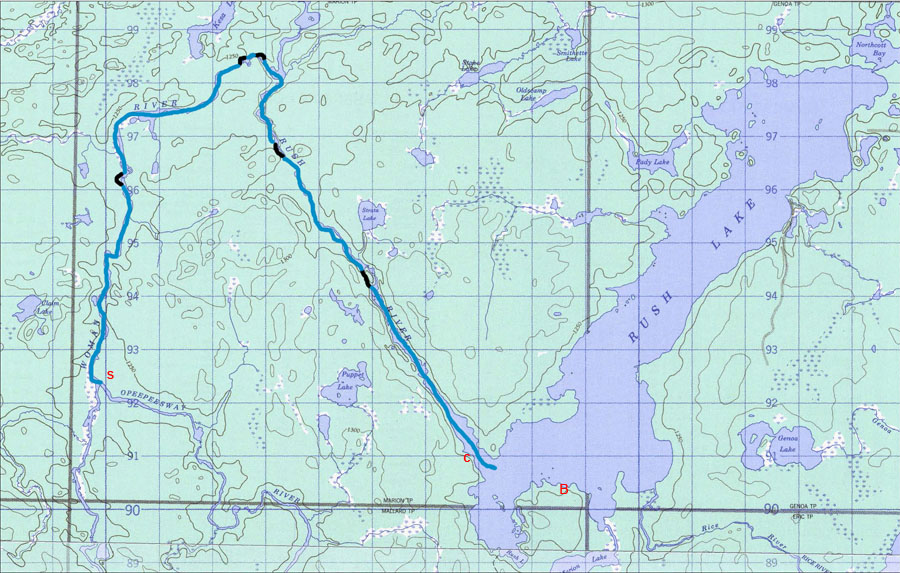
It takes us two days to get to Rush Lake ...
1976 Day 1
We camp along the river that first day and have enough time to explore around so we walk up the bank behind our site and find an old cabin and lots of racks of core samples. Someone in the past has done a lot of mineral exploration near here.
The second day see's us traveling down river to the junction with the Woman River. On the way we find a campsite occupied by prospectors ... we never met them but their identification and claim tags were in their big prospectors tent.
1976 Day 2
We camp that night in a small clearing that was obviously created by hunters who had been here for the moose hunt. The place was clean and in a perfect place to patrol the marshes along the Woman River and a fairly calm section of the Opeepeesway. It was a grassy spot and a bit buggy but it was home for the night.
Day three saw us reach Rush Lake where we camped toward the south end of the lake
1976 Day 3
There was a great beach at the south end of Rush lake ... marked on the map as B ... and we spent all our time during the day there.
The pike fishing was also next to phenominal ... the place was full of 5 to 6 pound pike ... if we wanted a pike dinner we'd go out fishing and within 15 minutes we'd have our fish.
The one disadvantage of the place was that there was an old logging road that came to the south end of the lake and a group of people from Michigan had discovered it.
To end our trip that year we just retraced our steps back to Opeepeesway Lake.
Over the next few years the road remained open and the fishing declined markedly.
However, this was a beautiful place and we continued to visit it on a regular basis.
We returned in 1977 and in 1978 we did the circle route by going over to Rice Lake and south to Little Rice Lake before returning to Opeepeesway Lake.
The one drawback to the circle trip was the portage from Rice to Little Rice ... it was difficult to find, not well marked and over 1500 yards long (the brochure said 900)
We continued to return over the years ... several times we drove into Rush Lake ... but the roads were closing in rapidly ... in 1999 we had to cut our way into Rush Lake after a big windstorm had blocked the last mile of the road ... it took us five hours to clear that mile.
As the 30th anniversary of that 1978 trip approached we talked about retracing the route ... we knew that the portages would be in terrible shape but we reasoned that we could get through ... and so we did ... but it instilled an interest in reopening some of the portages so that we (and others) might access this area more easily and enjoy some of our favourite vistas again.